Geolocate

Banisilan topographic map

Click on the map to display elevation.

About this map

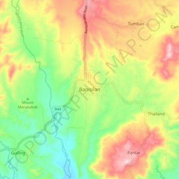
Name: Banisilan topographic map, elevation, terrain.

Location: Banisilan, North Cotabato, Soccsksargen, Philippines (7.46408 124.65463 7.54408 124.73463)

Average elevation: 1,286 ft

Minimum elevation: 748 ft

Maximum elevation: 1,946 ft

Other topographic maps

Click on a map to view its topography, its elevation and its terrain.

Makilala

Philippines > North Cotabato

Average elevation: 1,247 ft

New Israel

Philippines > North Cotabato > Makilala

Average elevation: 2,562 ft

Matalam

Philippines > North Cotabato

Average elevation: 413 ft

Pigcawayan

Philippines > North Cotabato

Average elevation: 436 ft

Antipas

Philippines > North Cotabato

Temperature ranges from 23 to 32 degrees Celsius, because of its topographic elevation of 320 meters above sea level and proximity to mountainous Bukidnon province, making it one of the cool places in Soccsksargen. The highest temperature is felt during the months of March and April, while the lowest is in…

Average elevation: 974 ft

Kidapawan

Philippines > North Cotabato

Located in Kidapawan is the Paniki Falls Eco-River Park located at Umpan Village, Barangay Balabag. Kidapawan is also one of the most well-known starting points for trekking on Mount Apo via the city's Lake Agco in Barangay Ilomavis, Kidapawan-Santa Cruz, and Kidapawan-Magpet trails which towers at 10,311 feet…

Average elevation: 1,621 ft

Gear up for your next adventure:

🌎3D Topographic Globes - Raised relief globes for a tactile understanding of geography
🗺️NatGeo Topo Maps - High-quality waterproof printed topographic maps of US Parks
🧺Microfiber Travel Towels - Compact and fast-drying towels for trail use
🪶Wildlife Field Guides - Learn animal tracking and species ID
📶Vehicle Signal Boosters - Improve reception in rural areas while driving to trailheads

As an Amazon Associate, this site earns from qualifying purchases at no extra cost to you.