
Make a donation
Gear up for your next adventure:
As an Amazon Associate, this site earns from qualifying purchases at no extra cost to you.
Chakrata topographic map
Click on the map to display elevation.
Make a donation
Gear up for your next adventure:
As an Amazon Associate, this site earns from qualifying purchases at no extra cost to you.
Chakrata
It lies between the Tons and Yamuna rivers, at an elevation of 2118 m, 98 km from the state capital, Dehradun. Chakrata was originally a cantonment of the British Indian Army. To the west lies Himachal Pradesh, and to the east are Mussoorie (73 km) and Tehri Garhwal.
Make a donation
Gear up for your next adventure:
As an Amazon Associate, this site earns from qualifying purchases at no extra cost to you.
About this map
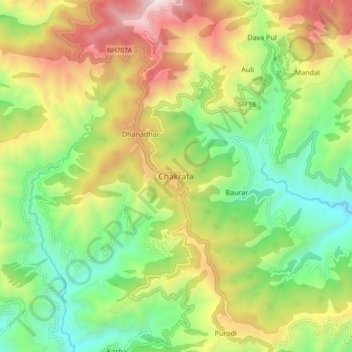
Name: Chakrata topographic map, elevation, terrain.
Location: Chakrata, Dehradun, Uttarakhand, 248123, India (30.66132 77.83034 30.74132 77.91034)
Average elevation: 6,073 ft
Minimum elevation: 4,003 ft
Maximum elevation: 9,121 ft
Make a donation
Gear up for your next adventure:
As an Amazon Associate, this site earns from qualifying purchases at no extra cost to you.