Geolocate

Cariño topographic map

Click on the map to display elevation.

About this map
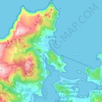
Name: Cariño topographic map, elevation, terrain.

Location: Cariño, Ortegal, A Coruña, Galicia, Spain (43.68335 -7.95508 43.77374 -7.85010)

Average elevation: 512 ft

Minimum elevation: -3 ft

Maximum elevation: 1,988 ft

Other topographic maps

Click on a map to view its topography, its elevation and its terrain.
A Felgueira

Spain > Galicia > Ortegal > Cariño

Average elevation: 364 ft

Fercoi

Spain > Galicia > Ortegal > Cerdido

Average elevation: 748 ft

Chao

Spain > Galicia > Ortegal > Mañón

Average elevation: 1,161 ft

O Picón

Spain > Galicia > Ortegal > Ortigueira

Average elevation: 118 ft

Miudelos

Spain > Galicia > Ortegal > Ortigueira

Average elevation: 144 ft

Gear up for your next adventure:

🛡️Insect Repellent - Protection against bugs during outdoor activities
🧭Compass with Lanyard - Easy‑carry compass for navigation
🪶Paracord Bracelet - Survival bracelet with built‑in tools
🧯Portable Fire Pit - Compact fire pit for camping spots
📷Action Cameras - Rugged cameras to document your journeys across rugged terrain

As an Amazon Associate, this site earns from qualifying purchases at no extra cost to you.