
Make a donation
Gear up for your next adventure:
As an Amazon Associate, this site earns from qualifying purchases at no extra cost to you.
São José do Rio Preto topographic map
Click on the map to display elevation.
Make a donation
Gear up for your next adventure:
As an Amazon Associate, this site earns from qualifying purchases at no extra cost to you.
São José do Rio Preto
São José do Rio Preto is located in northwest of the state of São Paulo in a region between the rivers Grande, Paraná and Tietê. The ecosystem in the region lies between the Cerrado (Brazilian savanna) with traces of the Atlantic Forest. Topographycally, it is characterized by a slightly undulated relief, with a medium elevation of 489 m (1,604 ft).
Make a donation
Gear up for your next adventure:
As an Amazon Associate, this site earns from qualifying purchases at no extra cost to you.
About this map
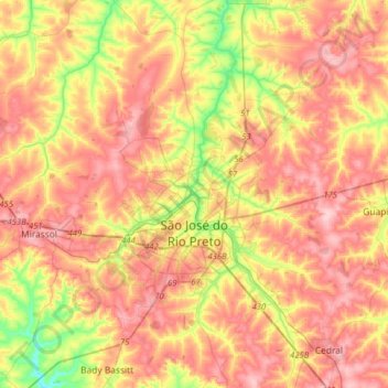
Name: São José do Rio Preto topographic map, elevation, terrain.
Average elevation: 1,729 ft
Minimum elevation: 1,411 ft
Maximum elevation: 1,975 ft
Make a donation
Gear up for your next adventure:
As an Amazon Associate, this site earns from qualifying purchases at no extra cost to you.