
Thank you for supporting this site ❤️
Make a donation
Make a donation
Gear up for your next adventure:
As an Amazon Associate, this site earns from qualifying purchases at no extra cost to you.
Monastir topographic map
Click on the map to display elevation.
Thank you for supporting this site ❤️
Make a donation
Make a donation
Gear up for your next adventure:
As an Amazon Associate, this site earns from qualifying purchases at no extra cost to you.
About this map
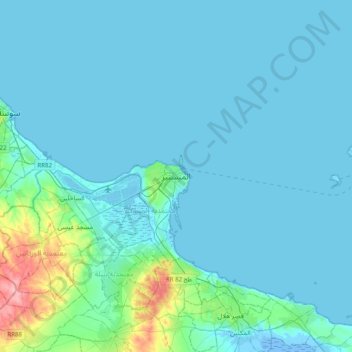
Name: Monastir topographic map, elevation, terrain.
Location: Monastir, Al Madina, Al Munastir, Monastir, 5000, Tunisia (35.61076 10.66805 35.93076 10.98805)
Average elevation: 36 ft
Minimum elevation: -39 ft
Maximum elevation: 374 ft
Thank you for supporting this site ❤️
Make a donation
Make a donation
Gear up for your next adventure:
As an Amazon Associate, this site earns from qualifying purchases at no extra cost to you.