
Make a donation
Gear up for your next adventure:
As an Amazon Associate, this site earns from qualifying purchases at no extra cost to you.
Phulbani topographic map
Click on the map to display elevation.
Make a donation
Gear up for your next adventure:
As an Amazon Associate, this site earns from qualifying purchases at no extra cost to you.
Phulbani
Phulbani is located at 20°28′N 84°14′E / 20.47°N 84.23°E / 20.47; 84.23. It has an average elevation of 485 metres (1591 feet).
Make a donation
Gear up for your next adventure:
As an Amazon Associate, this site earns from qualifying purchases at no extra cost to you.
About this map
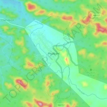
Name: Phulbani topographic map, elevation, terrain.
Location: Phulbani, Phulabani Town, Kandhamal, Odisha, 762001, India (20.43623 84.19485 20.51623 84.27485)
Average elevation: 1,703 ft
Minimum elevation: 1,440 ft
Maximum elevation: 2,369 ft
Make a donation
Gear up for your next adventure:
As an Amazon Associate, this site earns from qualifying purchases at no extra cost to you.