Geolocate

Wadesboro topographic map

Click on the map to display elevation.

About this map

Name: Wadesboro topographic map, elevation, terrain.

Location: Wadesboro, Anson County, North Carolina, 28170, United States (34.93745 -80.13996 34.98815 -80.03803)

Average elevation: 384 ft

Minimum elevation: 223 ft

Maximum elevation: 574 ft

Anson County trails, hiking, mountain biking, running and outdoor activities

Other topographic maps

Click on a map to view its topography, its elevation and its terrain.
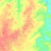
Kikers

United States > North Carolina > Anson County

Average elevation: 407 ft

Gear up for your next adventure:

🪶Camping Sleeping Pad - Comfortable sleeping pad for backpacking
🛡️Insect Repellent - Protection against bugs during outdoor activities
🥇GPS Hiking Watch - Multi‑sport GPS watch with navigation and trail tracking
🏫Relief Map Kits - Hands-on tools for teaching landforms and elevation
🗃️Trail First Aid Kit - Essential kit for outdoor injuries and emergencies

As an Amazon Associate, this site earns from qualifying purchases at no extra cost to you.