
Wolfhill topographic map
Interactive map
Click on the map to display elevation.
About this map
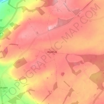
Name: Wolfhill topographic map, elevation, terrain.
Location: Wolfhill, Perth and Kinross, Scotland, PH2 6TH, United Kingdom (56.46518 -3.39304 56.50518 -3.35304)
Average elevation: 387 ft
Minimum elevation: 85 ft
Maximum elevation: 502 ft
Other topographic maps
Click on a map to view its topography, its elevation and its terrain.
Culteuchar
United Kingdom > Scotland > Perth and Kinross > Perth
Culteuchar, Perth, Perth and Kinross, Scotland, PH2 9HL, United Kingdom
Average elevation: 636 ft
Bridge of Earn
United Kingdom > Scotland > Perth and Kinross
Bridge of Earn, Perth and Kinross, Scotland, PH2 9PL, United Kingdom
Average elevation: 230 ft
Muthill
United Kingdom > Scotland > Perth and Kinross
Muthill, Perth and Kinross, Scotland, PH5 2AW, United Kingdom
Average elevation: 279 ft
Blairgowrie and Rattray
United Kingdom > Scotland > Perth and Kinross
Blairgowrie and Rattray, Perth and Kinross, Scotland, PH10 6AB, United Kingdom
Average elevation: 397 ft
Forgandenny
United Kingdom > Scotland > Perth and Kinross
Forgandenny, Perth and Kinross, Scotland, PH2 9EQ, United Kingdom
Average elevation: 174 ft