
Make a donation
Gear up for your next adventure:
As an Amazon Associate, this site earns from qualifying purchases at no extra cost to you.
El Aouana topographic map
Click on the map to display elevation.
Make a donation
Gear up for your next adventure:
As an Amazon Associate, this site earns from qualifying purchases at no extra cost to you.
About this map
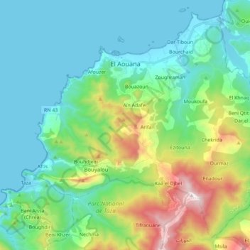
Name: El Aouana topographic map, elevation, terrain.
Location: El Aouana, El Aouana District, Jijel, 18005, Algeria (36.67527 5.54021 36.80028 5.71305)
Average elevation: 863 ft
Minimum elevation: -3 ft
Maximum elevation: 3,632 ft
Make a donation
Gear up for your next adventure:
As an Amazon Associate, this site earns from qualifying purchases at no extra cost to you.
Other topographic maps
Click on a map to view its topography, its elevation and its terrain.
Taza National Park
Algeria > Jijel > El Aouana District > Selma Ben Ziada
At lower altitudes, the Guerrouch forest is largely dominated by cork oaks, but higher up Algerian chestnut-leaved oak (Quercus afares) and Algerian oak (Quercus canariensis) are also present and there is a plentiful understorey of bird cherry (Prunus avium), Mediterranean willow (Salix pedicellata), European…
Average elevation: 1,434 ft