
Punta Leysser topographic map
Interactive map
Click on the map to display elevation.
About this map
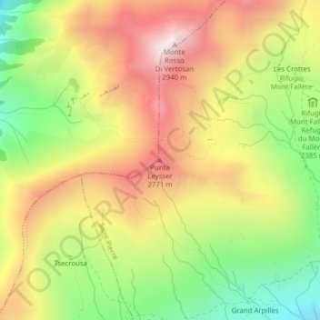
Name: Punta Leysser topographic map, elevation, terrain.
Location: Punta Leysser, Saint-Pierre, Vallée d'Aoste, Italie (45.75714 7.16265 45.75724 7.16275)
Average elevation: 8,077 ft
Minimum elevation: 6,512 ft
Maximum elevation: 9,600 ft
Other topographic maps
Click on a map to view its topography, its elevation and its terrain.
Vetan Villette
Italie > Vallée d'Aoste > Saint-Pierre
Vetan Villette, Saint-Pierre, Vallée d'Aoste, 11018, Italie
Average elevation: 5,650 ft