
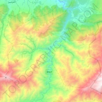
Imgdal topographic map
Interactive map
Click on the map to display elevation.
About this map
Name: Imgdal topographic map, elevation, terrain.
Average elevation: 5,692 ft
Minimum elevation: 2,444 ft
Maximum elevation: 11,434 ft
Other topographic maps
Click on a map to view its topography, its elevation and its terrain.
Kasbah Talat n'Yacoub
Maroc > cercle d'Asni > Tikiout > Talat-n-Ya’qoub
Kasbah Talat n'Yacoub, RN7, Talat-n-Ya’qoub, Tikiout, Talat N'Yaaqoub, caïdat de Talat N'Yaaqoub, cercle d'Asni, Province d'Al Haouz, Marrakech-Safi, 42353, Maroc
Average elevation: 4,298 ft
Toubkal
Maroc > cercle d'Asni > Asni
Toubkal, Asni, caïdat d'Asni, cercle d'Asni, Province d'Al Haouz, Marrakech-Safi, Maroc
Average elevation: 11,860 ft
Ras Ouanoukrim
Maroc > cercle d'Asni > Ijoukak
Ras Ouanoukrim, Ijoukak, caïdat de Talat N'Yaaqoub, cercle d'Asni, Province d'Al Haouz, Marrakech-Safi, Maroc
Average elevation: 12,162 ft
Imlil
Maroc > cercle d'Asni > Imlil
Imlil, Asni, caïdat d'Asni, cercle d'Asni, Province d'Al Haouz, Marrakech-Safi, 42000, Maroc
Average elevation: 7,572 ft
Refuge CAF du Toubkal
Maroc > cercle d'Asni > Asni > Sidi Chamarouch
Refuge CAF du Toubkal, Arumd-Sidi Chamarouch-CAF Refuge, Sidi Chamarouch, Asni, caïdat d'Asni, cercle d'Asni, Province d'Al Haouz, Marrakech-Safi, 42000, Maroc
Average elevation: 11,549 ft