
太华镇 topographic map
Interactive map
Click on the map to display elevation.
About this map
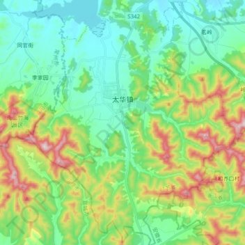
Name: 太华镇 topographic map, elevation, terrain.
Location: 太华镇, 宜兴市, 无锡市, 江苏省, 214200, 中国 (31.10415 119.52504 31.23528 119.65804)
Average elevation: 584 ft
Minimum elevation: 69 ft
Maximum elevation: 1,808 ft
Other topographic maps
Click on a map to view its topography, its elevation and its terrain.