
Moss Beach topographic map
Click on the map to display elevation.
About this map
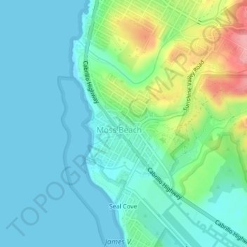
Name: Moss Beach topographic map, elevation, terrain.
Average elevation: 89 ft
Minimum elevation: 0 ft
Maximum elevation: 364 ft
San Mateo County trails, hiking, mountain biking, running and outdoor activities
Other topographic maps
Click on a map to view its topography, its elevation and its terrain.
Upper Crystal Springs Reservoir
United States > California > San Mateo County
Average elevation: 394 ft
Pacifica
United States > California > San Mateo County > Pacifica > Pacifica
Average elevation: 305 ft
Burlingame
United States > California > San Mateo County > Burlingame > Burlingame
Average elevation: 184 ft
San Carlos
United States > California > San Mateo County > San Carlos > San Carlos
Average elevation: 154 ft
Pillar Point Harbor
United States > California > San Mateo County > El Granada
Average elevation: 43 ft
Half Moon Bay
United States > California > San Mateo County > Half Moon Bay > Half Moon Bay
Average elevation: 240 ft
Coyote Point Recreation Area
United States > California > San Mateo County > San Mateo
Average elevation: 3 ft
Westborough
United States > California > San Mateo County > South San Francisco
Average elevation: 394 ft