
Bingerville topographic map
Interactive map
Click on the map to display elevation.
About this map
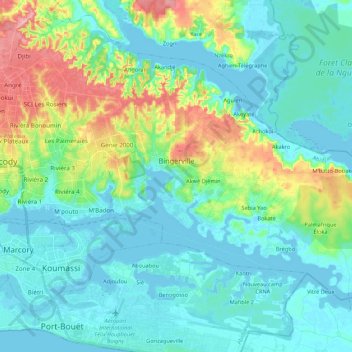
Name: Bingerville topographic map, elevation, terrain.
Location: Bingerville, Abidjan, Côte d'Ivoire (5.27283 -3.93325 5.42398 -3.71774)
Average elevation: 89 ft
Minimum elevation: -16 ft
Maximum elevation: 394 ft
Other topographic maps
Click on a map to view its topography, its elevation and its terrain.
Port-Bouët
Côte d'Ivoire > Abidjan > Port-Bouët
Port-Bouët, Abidjan, 12, Côte d'Ivoire
Average elevation: 39 ft