
Thank you for supporting this site ❤️
Make a donation
Make a donation
Gear up for your next adventure:
As an Amazon Associate, this site earns from qualifying purchases at no extra cost to you.
Gardunha topographic map
Click on the map to display elevation.
Thank you for supporting this site ❤️
Make a donation
Make a donation
Gear up for your next adventure:
As an Amazon Associate, this site earns from qualifying purchases at no extra cost to you.
About this map
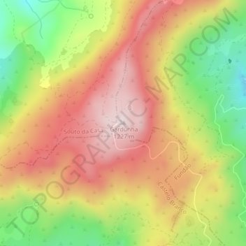
Name: Gardunha topographic map, elevation, terrain.
Location: Gardunha, Castelo Novo, Fundão, Castelo Branco, Portugal (40.08059 -7.52501 40.08069 -7.52491)
Average elevation: 3,330 ft
Minimum elevation: 2,480 ft
Maximum elevation: 3,999 ft
Thank you for supporting this site ❤️
Make a donation
Make a donation
Gear up for your next adventure:
As an Amazon Associate, this site earns from qualifying purchases at no extra cost to you.