
Monori járás topographic map
Interactive map
Click on the map to display elevation.
About this map
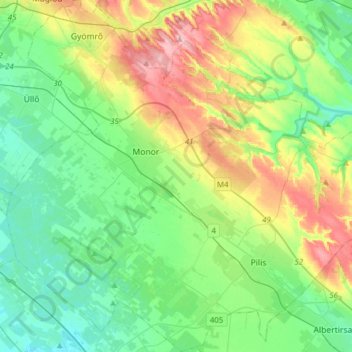
Name: Monori járás topographic map, elevation, terrain.
Location: Monori járás, Pest megye, Central Hungary, Hungary (47.23249 19.32322 47.44375 19.62132)
Average elevation: 489 ft
Minimum elevation: 354 ft
Maximum elevation: 784 ft
Other topographic maps
Click on a map to view its topography, its elevation and its terrain.
Budaörsi-hegy
Hungary > Pest megye > Budaörs
Budaörsi-hegy, Budaörs, Budakeszi járás, Pest megye, Central Hungary, 2040, Hungary
Average elevation: 1,152 ft