
Coux-et-Bigaroque topographic map
Interactive map
Click on the map to display elevation.
About this map
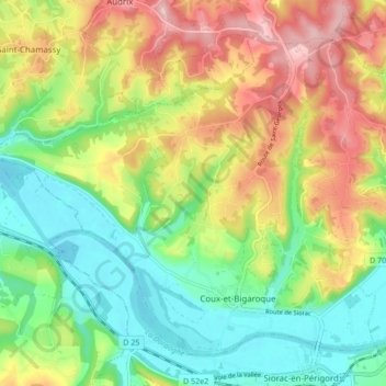
Name: Coux-et-Bigaroque topographic map, elevation, terrain.
Average elevation: 427 ft
Minimum elevation: 157 ft
Maximum elevation: 807 ft
Other topographic maps
Click on a map to view its topography, its elevation and its terrain.
La Geneste
Frankrijk > Nieuw-Aquitanië > Dordogne > Coux et Bigaroque-Mouzens > La Geneste
La Geneste, Coux-et-Bigaroque, Coux et Bigaroque-Mouzens, Sarlat-la-Canéda, Dordogne, Nieuw-Aquitanië, Metropolitaans Frankrijk, 24220, Frankrijk
Average elevation: 361 ft