
Andocs topographic map
Interactive map
Click on the map to display elevation.
About this map
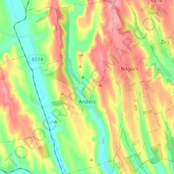
Name: Andocs topographic map, elevation, terrain.
Average elevation: 620 ft
Minimum elevation: 456 ft
Maximum elevation: 817 ft
Other topographic maps
Click on a map to view its topography, its elevation and its terrain.
Fiad
Fiad, Tabi járás, Somogy vármegye, Zuid-Transdanubië, Transdanubië, Hongarije
Average elevation: 653 ft
Balatonberény
Balatonberény, Marcali járás, Somogy vármegye, Zuid-Transdanubië, Transdanubië, 8649, Hongarije
Average elevation: 400 ft