Geolocate

Benin City topographic map

Click on the map to display elevation.

About this map
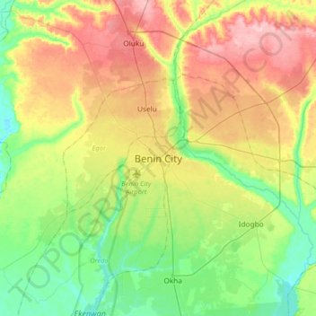
Name: Benin City topographic map, elevation, terrain.

Location: Benin City, Oredo, Edo State, 300241, Nigeria (6.17306 5.46211 6.49306 5.78211)

Average elevation: 236 ft

Minimum elevation: 7 ft

Maximum elevation: 581 ft

Other topographic maps

Click on a map to view its topography, its elevation and its terrain.
River Ogba

Nigeria > Edo State > Oredo

Average elevation: 59 ft

River Ogba

Nigeria > Edo State > Oredo

Average elevation: 59 ft

Gear up for your next adventure:

📌Outdoor GPS Map App - Apps and devices for digital topographic navigation
🔥Camping Stove - Portable stove for camping and backcountry cooking
🌡️Handheld Weather Meters - Measure wind, temp, and pressure for safe mountain travel
🗻Climbing Gear Basics - Essential gear for beginner climbers
📱Heavy-Duty Phone Cases - Drop-proof and waterproof protection for outdoor navigation

As an Amazon Associate, this site earns from qualifying purchases at no extra cost to you.