Geolocate

Watertown topographic map

Click on the map to display elevation.

About this map
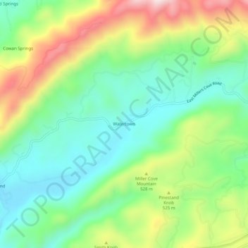
Name: Watertown topographic map, elevation, terrain.

Location: Watertown, Blount County, East Tennessee, Tennessee, 37886, United States (35.71814 -83.80795 35.75814 -83.76795)

Average elevation: 1,467 ft

Minimum elevation: 922 ft

Maximum elevation: 2,444 ft

Blount County trails, hiking, mountain biking, running and outdoor activities

Other topographic maps

Click on a map to view its topography, its elevation and its terrain.
Eagleton Village

United States > Tennessee > Blount County

Average elevation: 951 ft

Rowans Creek

United States > Tennessee > Blount County

Average elevation: 3,747 ft

Calderwood Lake

United States > Tennessee > Blount County

Average elevation: 1,657 ft

Gear up for your next adventure:

📦Gear Storage Bags - Organize and protect outdoor equipment
🥾Women's Hiking Boots - Top-rated trail boots with ankle support and superior grip
🗺️NatGeo Topo Maps - High-quality waterproof printed topographic maps of US Parks
📷Action Cameras - Rugged cameras to document your journeys across rugged terrain
🛰️Satellite Messengers - Emergency SOS and two-way messaging for off-grid adventures

As an Amazon Associate, this site earns from qualifying purchases at no extra cost to you.