
Three Oaks topographic map
Interactive map
Click on the map to display elevation.
About this map
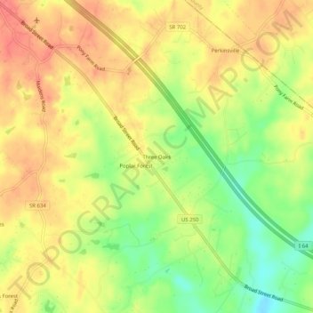
Name: Three Oaks topographic map, elevation, terrain.
Location: Three Oaks, Goochland County, Virginia, 23102, United States (37.71098 -77.85444 37.75098 -77.81444)
Average elevation: 302 ft
Minimum elevation: 184 ft
Maximum elevation: 384 ft
Other topographic maps
Click on a map to view its topography, its elevation and its terrain.
Manakin Farms
United States > Virginia > Goochland County > Manakin
Manakin Farms, Manakin, Goochland County, Virginia, 23103, United States
Average elevation: 217 ft
Sandy Hook
United States > Virginia > Goochland County
Sandy Hook, Goochland County, Virginia, 23153, United States
Average elevation: 318 ft
Shannon Hill
United States > Virginia > Goochland County
Shannon Hill, Goochland County, Virginia, 23084, United States
Average elevation: 456 ft
Maidens Forest
United States > Virginia > Goochland County
Maidens Forest, Goochland County, Virginia, 23102, United States
Average elevation: 289 ft
Goochland
United States > Virginia > Goochland County > Goochland
Goochland, Goochland County, Virginia, 23014, United States
Average elevation: 243 ft
Oaklands
United States > Virginia > Goochland County > Oaklands
Oaklands, Goochland County, Virginia, 23102, United States
Average elevation: 262 ft
James River Landing
United States > Virginia > Goochland County > James River Landing
James River Landing, Goochland County, Virginia, United States
Average elevation: 276 ft
Amber Lake
United States > Virginia > Goochland County > Amber Lake
Amber Lake, Goochland County, Virginia, 23039, United States
Average elevation: 295 ft