
Bílý Potok topographic map
Interactive map
Click on the map to display elevation.
About this map
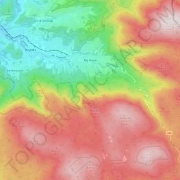
Name: Bílý Potok topographic map, elevation, terrain.
Location: Bílý Potok, okres Liberec, Liberecký kraj, 463 63, Czechia (50.83371 15.19470 50.88811 15.31483)
Average elevation: 2,480 ft
Minimum elevation: 1,138 ft
Maximum elevation: 3,688 ft
Other topographic maps
Click on a map to view its topography, its elevation and its terrain.
Bohuslav
Czechia > Liberecký kraj > Hrubá Skála
Bohuslav, Hrubá Skála, okres Semily, Liberecký kraj, 512 64, Czechia
Average elevation: 1,073 ft