Geolocate

Canlaon topographic map

Click on the map to display elevation.

About this map
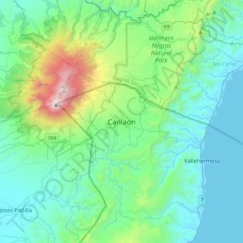
Name: Canlaon topographic map, elevation, terrain.

Location: Canlaon, Negros Oriental, Central Visayas, 6223, Philippines (10.22695 123.05862 10.54695 123.37862)

Average elevation: 1,417 ft

Minimum elevation: -7 ft

Maximum elevation: 7,969 ft

Other topographic maps

Click on a map to view its topography, its elevation and its terrain.

La Paz

Philippines > Negros Oriental > Bais

Average elevation: 49 ft

Cantil-e

Philippines > Negros Oriental > Dumaguete

Average elevation: 253 ft

Lake Balinsasayao

Philippines > Negros Oriental > Sibulan

Average elevation: 3,169 ft

Sibulan

Philippines > Negros Oriental

Average elevation: 712 ft

Gear up for your next adventure:

🪄Magnetic Compass - Accurate compass for navigation
🪶Survival Guide Book - Expert advice for emergency preparedness
☕Camping Coffee Makers - Enjoy premium coffee at the summit or campsite
🧢Outdoor Hiking Hat - Sun protection hat for outdoor explorers
🧣Merino Neck Gaiters - Multi-functional headwear for wind and sun protection

As an Amazon Associate, this site earns from qualifying purchases at no extra cost to you.