
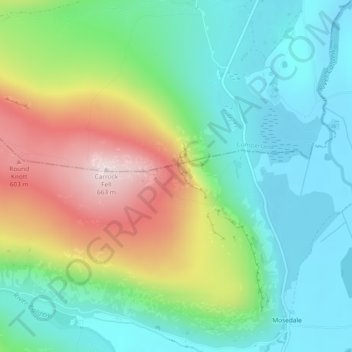
The Trough topographic map
Interactive map
Click on the map to display elevation.
About this map
Name: The Trough topographic map, elevation, terrain.
Average elevation: 1,171 ft
Minimum elevation: 686 ft
Maximum elevation: 2,149 ft
Other topographic maps
Click on a map to view its topography, its elevation and its terrain.
Pooley Bridge
United Kingdom > England > Eden > Pooley Bridge
Pooley Bridge, Eden, Cumbria, North West England, England, CA10 2NL, United Kingdom
Average elevation: 689 ft
Martindale
United Kingdom > England > Eden > Martindale
Martindale, Eden, Cumbria, North West England, England, United Kingdom
Average elevation: 1,263 ft
Eden
United Kingdom > England > Eden
Eden, Cumbria, North West England, England, United Kingdom
Average elevation: 1,043 ft
Cross Fell
United Kingdom > England > Eden
Cross Fell, Eden, Cumbria, North West England, England, United Kingdom
Average elevation: 2,470 ft