
Bricket Wood topographic map
Interactive map
Click on the map to display elevation.
About this map
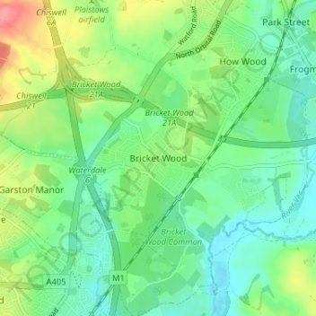
Name: Bricket Wood topographic map, elevation, terrain.
Average elevation: 269 ft
Minimum elevation: 187 ft
Maximum elevation: 440 ft
Other topographic maps
Click on a map to view its topography, its elevation and its terrain.
Home Wood
United Kingdom > England > Hertfordshire > St Albans > Sandridge
Home Wood, Marshalswick, Sandridge, St Albans, Hertfordshire, England, AL4 0XR, United Kingdom
Average elevation: 295 ft
Harpenden
United Kingdom > England > Hertfordshire > St Albans > Hatching Green
Harpenden, Hatching Green, St Albans, Hertfordshire, England, United Kingdom
Average elevation: 390 ft
Kinsbourne Green
United Kingdom > England > Hertfordshire > St Albans
Kinsbourne Green, Harpenden Rural, St Albans, Hertfordshire, England, AL5 3PJ, United Kingdom
Average elevation: 440 ft