
Rubihorn topographic map
Interactive map
Click on the map to display elevation.
About this map
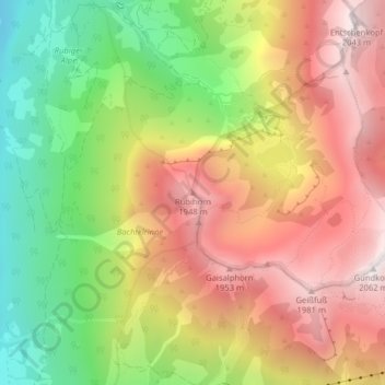
Name: Rubihorn topographic map, elevation, terrain.
Average elevation: 4,813 ft
Minimum elevation: 2,815 ft
Maximum elevation: 6,673 ft
Other topographic maps
Click on a map to view its topography, its elevation and its terrain.
Allgäuer Alpen
Deutschland > Bayern > Oberstdorf
Allgäuer Alpen, Bayern, Deutschland
Average elevation: 4,268 ft
Nebelhorn
Deutschland > Bayern > Oberstdorf
Nebelhorn, Oberstdorf, Landkreis Oberallgäu, Bayern, Deutschland
Average elevation: 5,879 ft
Schwand
Deutschland > Bayern > Oberstdorf > Schwand
Schwand, Oberstdorf, Landkreis Oberallgäu, Bayern, 87561, Deutschland
Average elevation: 3,940 ft
Hoher Ifen
Deutschland > Bayern > Oberstdorf
Hoher Ifen, Oberstdorf, Landkreis Oberallgäu, Schwaben, Bayern, Deutschland
Average elevation: 5,991 ft
Kleiner Wilder
Deutschland > Bayern > Oberstdorf
Kleiner Wilder, Oberstdorf, Landkreis Oberallgäu, Schwaben, Bayern, Deutschland
Average elevation: 6,033 ft
Höfats Ostgipfel
Deutschland > Bayern > Oberstdorf
Höfats Ostgipfel, Oberstdorf, Landkreis Oberallgäu, Schwaben, Bayern, Deutschland
Average elevation: 5,233 ft
Bockkarkopf
Deutschland > Bayern > Oberstdorf
Bockkarkopf, Oberstdorf, Landkreis Oberallgäu, Schwaben, Bayern, Deutschland
Average elevation: 7,054 ft
Mädelegabel
Deutschland > Bayern > Oberstdorf
Mädelegabel, Oberstdorf, Landkreis Oberallgäu, Schwaben, Bayern, Deutschland
Average elevation: 6,867 ft
Kleiner Seekopf
Deutschland > Bayern > Oberstdorf
Kleiner Seekopf, Oberstdorf, Landkreis Oberallgäu, Schwaben, Bayern, Deutschland
Average elevation: 5,614 ft
Biberkopf
Deutschland > Bayern > Oberstdorf
Biberkopf, Oberstdorf, Landkreis Oberallgäu, Schwaben, Bayern, 6993, Deutschland
Average elevation: 6,417 ft
Trettach
Deutschland > Bayern > Oberstdorf
Trettach, Oberstdorf, Landkreis Oberallgäu, Schwaben, Bayern, 87561, Deutschland
Average elevation: 3,268 ft