
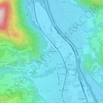
Niederaudorf topographic map
Interactive map
Click on the map to display elevation.
About this map
Name: Niederaudorf topographic map, elevation, terrain.
Average elevation: 1,936 ft
Minimum elevation: 1,499 ft
Maximum elevation: 4,606 ft
Other topographic maps
Click on a map to view its topography, its elevation and its terrain.
Rosengasse
Deutschland > Bayern > Landkreis Rosenheim > Oberaudorf
Rosengasse, Oberaudorf, Landkreis Rosenheim, Bayern, 83735, Deutschland
Average elevation: 4,134 ft
Buchau
Deutschland > Bayern > Landkreis Rosenheim > Oberaudorf
Buchau, Oberaudorf, Landkreis Rosenheim, Bayern, 83080, Deutschland
Average elevation: 2,874 ft
Innsiedlung
Deutschland > Bayern > Landkreis Rosenheim > Oberaudorf
Innsiedlung, Oberaudorf, Landkreis Rosenheim, Bayern, 83080, Deutschland
Average elevation: 1,729 ft
Tatzelwurm
Deutschland > Bayern > Landkreis Rosenheim > Oberaudorf
Tatzelwurm, Oberaudorf, Landkreis Rosenheim, Bayern, Deutschland
Average elevation: 3,268 ft
Seebach
Deutschland > Bayern > Landkreis Rosenheim > Oberaudorf
Seebach, Oberaudorf, Landkreis Rosenheim, Bayern, Deutschland
Average elevation: 3,054 ft
Unteres Sudelfeld
Deutschland > Bayern > Landkreis Rosenheim > Oberaudorf
Unteres Sudelfeld, Oberaudorf, Landkreis Rosenheim, Bayern, 83735, Deutschland
Average elevation: 3,757 ft