Geolocate

Geneva topographic map

Click on the map to display elevation.

About this map
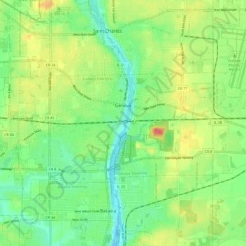
Name: Geneva topographic map, elevation, terrain.

Location: Geneva, Geneva Township, Kane County, Illinois, 60134, United States (41.86347 -88.37969 41.89892 -88.26232)

Average elevation: 751 ft

Minimum elevation: 659 ft

Maximum elevation: 892 ft

Kane County trails, hiking, mountain biking, running and outdoor activities

Other topographic maps

Click on a map to view its topography, its elevation and its terrain.
Elgin

United States > Illinois > Kane County

Average elevation: 837 ft

Elgin

United States > Illinois > Kane County

Average elevation: 837 ft

Campton Township

United States > Illinois > Kane County

Average elevation: 876 ft

Gear up for your next adventure:

🔊Portable Camp Speaker - Music and alerts at camp
🧭Hiking Compass - Precision compass for reliable navigation in the wilderness
🧭Map Reading Tools - Tools and kits for map navigation
🪶Paracord Bracelet - Survival bracelet with built‑in tools
🧥Waterproof Jacket for Hiking - Breathable and rugged rain jacket for outdoor excursions

As an Amazon Associate, this site earns from qualifying purchases at no extra cost to you.