
Thank you for supporting this site ❤️
Make a donation
Make a donation
Gear up for your next adventure:
As an Amazon Associate, this site earns from qualifying purchases at no extra cost to you.
寿宁县 topographic map
Click on the map to display elevation.
Thank you for supporting this site ❤️
Make a donation
Make a donation
Gear up for your next adventure:
As an Amazon Associate, this site earns from qualifying purchases at no extra cost to you.
寿宁县
属亚热带海洋性季风气候,境内海拔跨度大,垂直差异明显,昼夜温差大,雨量充沛,四季分明。全县山地面积1167.2平方公里,占总面积的88.9%,有“九山半水半分田”的说法。最高峰山羊尖海拔1649米,最低的武曲村海拔只有60米。
Thank you for supporting this site ❤️
Make a donation
Make a donation
Gear up for your next adventure:
As an Amazon Associate, this site earns from qualifying purchases at no extra cost to you.
About this map
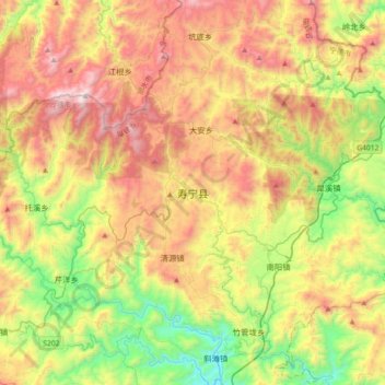
Name: 寿宁县 topographic map, elevation, terrain.
Location: 寿宁县, 宁德市, 福建省, 中国 (27.29698 119.35014 27.61698 119.67014)
Average elevation: 2,507 ft
Minimum elevation: 322 ft
Maximum elevation: 5,269 ft
Thank you for supporting this site ❤️
Make a donation
Make a donation
Gear up for your next adventure:
As an Amazon Associate, this site earns from qualifying purchases at no extra cost to you.