
Town of Redfield topographic map
Interactive map
Click on the map to display elevation.
About this map
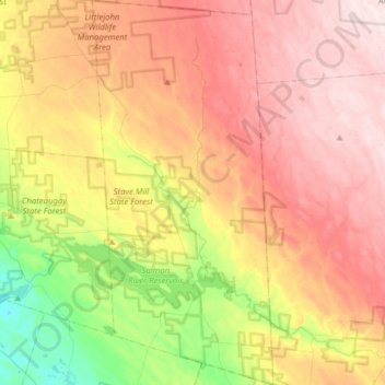
Name: Town of Redfield topographic map, elevation, terrain.
Average elevation: 1,296 ft
Minimum elevation: 574 ft
Maximum elevation: 1,942 ft
Other topographic maps
Click on a map to view its topography, its elevation and its terrain.
City of Fulton
United States > New York > Oswego County
City of Fulton, Oswego County, New York, 13069, United States
Average elevation: 374 ft
Lansing
United States > New York > Oswego County
Lansing, Town of Scriba, Oswego County, New York, 13126, United States
Average elevation: 377 ft
Union Settlement
United States > New York > Oswego County > Town of West Monroe
Union Settlement, Town of West Monroe, Oswego County, New York, 13167, United States
Average elevation: 502 ft
Altmar
United States > New York > Oswego County
Altmar, Town of Albion, Oswego County, New York, United States
Average elevation: 574 ft
Town of Orwell
United States > New York > Oswego County
Town of Orwell, Albion, Oswego County, New York, United States
Average elevation: 745 ft
Town of Palermo
United States > New York > Oswego County
Town of Palermo, Oswego County, New York, United States
Average elevation: 440 ft
Town of Mexico
United States > New York > Oswego County
Town of Mexico, Oswego County, New York, 13114, United States
Average elevation: 390 ft
Colosse
United States > New York > Oswego County > Town of Mexico
Colosse, Town of Mexico, Albion, Oswego County, New York, 13131, United States
Average elevation: 446 ft
Village of Phoenix
United States > New York > Oswego County > Town of Schroeppel
Village of Phoenix, Town of Schroeppel, Oswego County, New York, United States
Average elevation: 384 ft
Town of Amboy
United States > New York > Oswego County
Town of Amboy, Oswego County, New York, United States
Average elevation: 636 ft
Mud Hill
United States > New York > Oswego County > Town of Amboy
Mud Hill, Town of Amboy, Oswego County, New York, 13493, United States
Average elevation: 699 ft
Redfield
United States > New York > Oswego County > Redfield
Redfield, Town of Redfield, Oswego County, New York, 13437, United States
Average elevation: 1,043 ft
Fulton
United States > New York > Oswego County > Fulton
Fulton, Oswego County, New York, 13069-2934, United States
Average elevation: 397 ft
Town of Albion
United States > New York > Oswego County
Town of Albion, Oswego County, New York, 13302, United States
Average elevation: 587 ft
Oneida Lake
United States > New York > Oswego County > Town of Constantia
Oneida Lake, Town of Constantia, Town of Lenox, Oswego County, New York, United States
Average elevation: 453 ft
Village of Parish
United States > New York > Oswego County > Town of Parish
Village of Parish, Town of Parish, Albion, Oswego County, New York, United States
Average elevation: 482 ft
City of Oswego
United States > New York > Oswego County
City of Oswego, Oswego County, New York, 13126, United States
Average elevation: 285 ft
Village of Pulaski
United States > New York > Oswego County > Town of Richland > Village of Pulaski
Village of Pulaski, Town of Richland, Oswego County, New York, United States
Average elevation: 384 ft