
Watkins Glen State Park topographic map
Interactive map
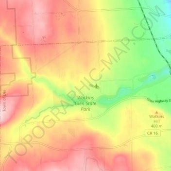
Click on the map to display elevation.
About this map
Name: Watkins Glen State Park topographic map, elevation, terrain.
Average elevation: 1,286 ft
Minimum elevation: 827 ft
Maximum elevation: 1,640 ft
During the Pleistocene era, a vast area was covered by ice during the maximum extent of glacial ice in the north polar area. The movement of glaciers from the Laurentide and Wisconsin ice sheets shaped the Finger Lakes region. The lakes originated as a series of northward-flowing streams. Around two million years ago the first of many continental glaciers of the Laurentide Ice Sheet moved southward from the Hudson Bay area, initiating the Pleistocene glaciation. These glaciers widened, deepened and accentuated the existing river valleys. Glacial debris, possibly including terminal moraines, left behind by the receding ice acted as dams, allowing lakes to form. Despite the deep erosion of the valleys, the surrounding uplands show little evidence of glaciation, suggesting that the ice was thin, or at least unable to cause much erosion at these higher altitudes. The deep cutting of the valleys by the ice left some tributaries hanging high above the lakes: both Seneca and Cayuga have tributaries hanging as much as 390 feet (120 m) above the valley floors.