
Marymoor Park topographic map
Interactive map
Click on the map to display elevation.
About this map
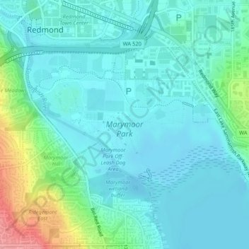
Name: Marymoor Park topographic map, elevation, terrain.
Average elevation: 75 ft
Minimum elevation: 10 ft
Maximum elevation: 344 ft
Other topographic maps
Click on a map to view its topography, its elevation and its terrain.
Earlmont
United States > Washington > King County > Redmond
Earlmont, Redmond, King County, Washington, 98952, United States
Average elevation: 174 ft
Redmond West Wetlands
United States > Washington > King County > Redmond
Redmond West Wetlands, Microsoft Redwest Campus, Redmond, King County, Washington, 98052, United States
Average elevation: 259 ft