
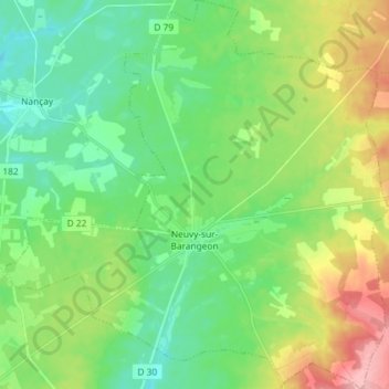
Neuvy-sur-Barangeon topographic map
Interactive map
Click on the map to display elevation.
About this map
Name: Neuvy-sur-Barangeon topographic map, elevation, terrain.
Average elevation: 528 ft
Minimum elevation: 397 ft
Maximum elevation: 797 ft
Other topographic maps
Click on a map to view its topography, its elevation and its terrain.
Ivry
France > Centre-Val de Loire > Cher > Vasselay
Ivry, Vasselay, Bourges, Cher, Centre-Val de Loire, Metropolitan France, 18110, France
Average elevation: 522 ft
Le Goyer
France > Centre-Val de Loire > Cher > Vierzon
Le Goyer, Vierzon, Cher, Centre-Val de Loire, Metropolitan France, 18100, France
Average elevation: 443 ft
Blet
France > Centre-Val de Loire > Cher
Blet, Saint-Amand-Montrond, Cher, Centre-Val de Loire, Metropolitan France, 18350, France
Average elevation: 669 ft
Flavigny
France > Centre-Val de Loire > Cher
Flavigny, Saint-Amand-Montrond, Cher, Centre-Val de Loire, Metropolitan France, 18350, France
Average elevation: 669 ft
Quincy
France > Centre-Val de Loire > Cher
Quincy, Vierzon, Cher, Centre-Val de Loire, Metropolitan France, 18120, France
Average elevation: 404 ft
Diane, 18370
France > Centre-Val de Loire > Cher > Préveranges
Diane, 18370, Préveranges, Saint-Amand-Montrond, Cher, Centre-Val de Loire, Metropolitan France, 18370, France
Average elevation: 1,204 ft
Raymond
France > Centre-Val de Loire > Cher
Raymond, Saint-Amand-Montrond, Cher, Centre-Val de Loire, Metropolitan France, 18130, France
Average elevation: 614 ft
Bourges
France > Centre-Val de Loire > Cher
Bourges, Cher, Centre-Val de Loire, Metropolitan France, 18000, France
Average elevation: 479 ft