
Nohsngithiang Falls (Seven Sisters) topographic map
Interactive map
Click on the map to display elevation.
About this map
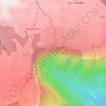
Name: Nohsngithiang Falls (Seven Sisters) topographic map, elevation, terrain.
Average elevation: 3,422 ft
Minimum elevation: 1,194 ft
Maximum elevation: 4,364 ft
Other topographic maps
Click on a map to view its topography, its elevation and its terrain.
Sohsarat
India > Meghalaya > Shella Bholaganj > Nongwar
Sohsarat, Nongwar, Shella Bholaganj, East Khasi Hills District, Meghalaya, India
Average elevation: 1,220 ft
Nongthymmai
India > Meghalaya > Shella Bholaganj
Nongthymmai, Shella Bholaganj, East Khasi Hills District, Meghalaya, 793108, India
Average elevation: 3,684 ft
Sohra (Cherrapunji)
India > Meghalaya > Shella Bholaganj
Sohra (Cherrapunji), Shella Bholaganj, East Khasi Hills, Meghalaya, 793108, India
Average elevation: 3,835 ft
Suktia
India > Meghalaya > Shella Bholaganj
Suktia, Shella Bholaganj, East Khasi Hills, Meghalaya, India
Average elevation: 1,594 ft
Nohkalikai Falls View Point
India > Meghalaya > Shella Bholaganj
Nohkalikai Falls View Point, Root bridge, Shella Bholaganj, East Khasi Hills, Meghalaya, 793108, India
Average elevation: 3,793 ft