
Alagnak River topographic map
Interactive map
Click on the map to display elevation.
About this map
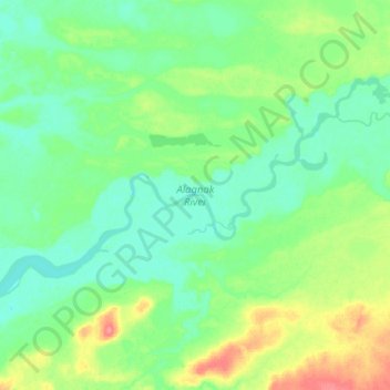
Name: Alagnak River topographic map, elevation, terrain.
Location: Alagnak River, Lake and Peninsula, Alaska, United States (59.00069 -156.84417 59.07177 -156.58744)
Average elevation: 52 ft
Minimum elevation: 3 ft
Maximum elevation: 190 ft
Other topographic maps
Click on a map to view its topography, its elevation and its terrain.
Aniakchak National Monument
United States > Alaska > Lake and Peninsula
Aniakchak National Monument, Lake and Peninsula, Alaska, United States
Average elevation: 1,234 ft
Lake Clark
United States > Alaska > Lake and Peninsula
Lake Clark, Lake and Peninsula, Alaska, United States
Average elevation: 1,565 ft
Port Alsworth
United States > Alaska > Lake and Peninsula
Port Alsworth, Lake and Peninsula, Alaska, 99653, United States
Average elevation: 305 ft
Nondalton
United States > Alaska > Lake and Peninsula
Nondalton, Lake and Peninsula, Alaska, 99640, United States
Average elevation: 453 ft