
Beechwood Village topographic map
Interactive map
Click on the map to display elevation.
About this map
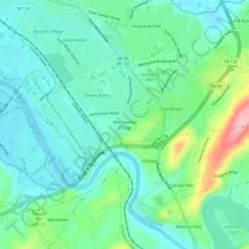
Name: Beechwood Village topographic map, elevation, terrain.
Average elevation: 1,312 ft
Minimum elevation: 1,178 ft
Maximum elevation: 1,729 ft
Other topographic maps
Click on a map to view its topography, its elevation and its terrain.
Fair Acres
United States > Tennessee > Sullivan County > Kingsport
Fair Acres, Kingsport, Sullivan County, East Tennessee, Tennessee, 37664, United States
Average elevation: 1,273 ft
Gibsontown
United States > Tennessee > Sullivan County > Kingsport
Gibsontown, Kingsport, Sullivan County, East Tennessee, Tennessee, 37660, United States
Average elevation: 1,273 ft
Preston Woods
United States > Tennessee > Sullivan County > Kingsport
Preston Woods, Kingsport, Sullivan County, Tennessee, 37664, United States
Average elevation: 1,417 ft
Brairwood Acres
United States > Tennessee > Sullivan County > Kingsport
Brairwood Acres, Kingsport, Sullivan County, Tennessee, 37664, United States
Average elevation: 1,476 ft
Kingsport
United States > Tennessee > Sullivan County > Kingsport
Kingsport, Sullivan County, Tennessee, 37660-3610, United States
Average elevation: 1,555 ft
Lynn Garden
United States > Tennessee > Sullivan County > Kingsport
Lynn Garden, Kingsport, Sullivan County, Tennessee, 37665, United States
Average elevation: 1,430 ft
Bloomington Heights
United States > Tennessee > Sullivan County > Kingsport
Bloomington Heights, Kingsport, Sullivan County, Tennessee, 37660, United States
Average elevation: 1,342 ft