
Browns Island (Motukorea) topographic map
Interactive map
Click on the map to display elevation.
About this map
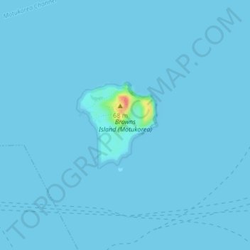
Name: Browns Island (Motukorea) topographic map, elevation, terrain.
Location: Browns Island (Motukorea), Waiheke, Auckland, New Zealand (-36.83602 174.88897 -36.82667 174.89995)
Average elevation: 3 ft
Minimum elevation: 0 ft
Maximum elevation: 177 ft
Other topographic maps
Click on a map to view its topography, its elevation and its terrain.
Rangitoto Island
New Zealand > Auckland > Waiheke
Rangitoto Island, Waiheke, Waitematā and Gulf Ward, Auckland, New Zealand
Average elevation: 98 ft
Waiheke Island
New Zealand > Auckland > Waiheke
Waiheke Island, Waiheke, Auckland, New Zealand
Average elevation: 52 ft