
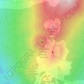
Hoyo de los Faros topographic map
Interactive map
Click on the map to display elevation.
About this map
Name: Hoyo de los Faros topographic map, elevation, terrain.
Average elevation: 4,446 ft
Minimum elevation: 2,989 ft
Maximum elevation: 6,007 ft
Other topographic maps
Click on a map to view its topography, its elevation and its terrain.
Volcán de Martín
Spanje > Canarische Eilanden > Fuencaliente de la Palma
Volcán de Martín, Fuencaliente de la Palma, Santa Cruz de Tenerife, Canarische Eilanden, 38749, Spanje
Average elevation: 4,373 ft
Montaña del Fuego
Spanje > Canarische Eilanden > Fuencaliente de la Palma
Montaña del Fuego, Fuencaliente de la Palma, Santa Cruz de Tenerife, Canarische Eilanden, 38749, Spanje
Average elevation: 3,520 ft