
Make a donation
Gear up for your next adventure:
As an Amazon Associate, this site earns from qualifying purchases at no extra cost to you.
Prats-de-Mollo-la-Preste topographic map
Click on the map to display elevation.
Make a donation
Gear up for your next adventure:
As an Amazon Associate, this site earns from qualifying purchases at no extra cost to you.
Prats-de-Mollo-la-Preste
Prats-de-Mollo-la-Preste is located in the Pyrenees, 13 km (8.1 mi) from the Spanish border and the Autonomous Community of Catalonia, on the banks of the river Tech, and on the south face of the Canigou at an elevation of 735 meters.
Make a donation
Gear up for your next adventure:
As an Amazon Associate, this site earns from qualifying purchases at no extra cost to you.
About this map
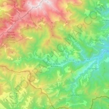
Name: Prats-de-Mollo-la-Preste topographic map, elevation, terrain.
Average elevation: 4,249 ft
Minimum elevation: 1,365 ft
Maximum elevation: 8,927 ft
Make a donation
Gear up for your next adventure:
As an Amazon Associate, this site earns from qualifying purchases at no extra cost to you.
Other topographic maps
Click on a map to view its topography, its elevation and its terrain.
Make a donation
Gear up for your next adventure:
As an Amazon Associate, this site earns from qualifying purchases at no extra cost to you.
L'Ermitage
France > Occitania > Pyrénées-Orientales > Font-Romeu-Odeillo-Via > L'Ermitage
Average elevation: 5,856 ft
Saint-Martin de l'Albère
France > Occitania > Pyrénées-Orientales > L'Albère
Average elevation: 2,244 ft
Make a donation
Gear up for your next adventure:
As an Amazon Associate, this site earns from qualifying purchases at no extra cost to you.
Station de Puyvalador
France > Occitania > Pyrénées-Orientales > Puyvalador
Average elevation: 5,801 ft
Les Escaldes
France > Occitania > Pyrénées-Orientales > Angoustrine-Villeneuve-des-Escaldes
Average elevation: 4,892 ft
Make a donation
Gear up for your next adventure:
As an Amazon Associate, this site earns from qualifying purchases at no extra cost to you.