Geolocate

Pidley topographic map

Click on the map to display elevation.

About this map

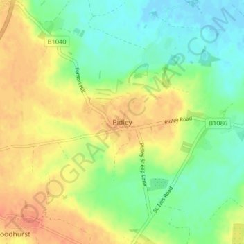
Name: Pidley topographic map, elevation, terrain.

Location: Pidley, Huntingdonshire, Cambridgeshire, Cambridgeshire and Peterborough, England, PE28 3BX, United Kingdom (52.36271 -0.06214 52.40271 -0.02214)

Average elevation: 66 ft

Minimum elevation: -13 ft

Maximum elevation: 138 ft

Other topographic maps

Click on a map to view its topography, its elevation and its terrain.

Gear up for your next adventure:

Camping Coffee Makers - Enjoy premium coffee at the summit or campsite
📱Heavy-Duty Phone Cases - Drop-proof and waterproof protection for outdoor navigation
🧥Waterproof Jacket for Hiking - Breathable and rugged rain jacket for outdoor excursions
🧯Emergency Survival Kit - All‑in‑one survival essentials for the backcountry
🦶Hiking Gaiters - Keep debris and water out of your boots

As an Amazon Associate, this site earns from qualifying purchases at no extra cost to you.