
Курган topographic map
Interactive map
Click on the map to display elevation.
About this map
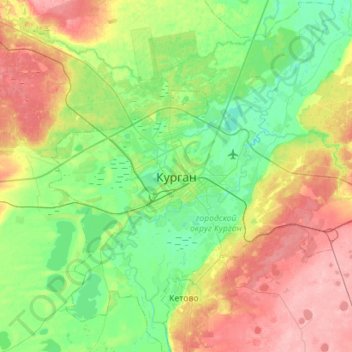
Name: Курган topographic map, elevation, terrain.
Average elevation: 305 ft
Minimum elevation: 194 ft
Maximum elevation: 509 ft
Other topographic maps
Click on a map to view its topography, its elevation and its terrain.
Тобол
Россия > Курганская область > городской округ Курган > Курган
Тобол, Курган, городской округ Курган, Курганская область, Уральский федеральный округ, Россия
Average elevation: 243 ft