
Make a donation
Gear up for your next adventure:
As an Amazon Associate, this site earns from qualifying purchases at no extra cost to you.
Lugoff topographic map
Click on the map to display elevation.
Make a donation
Gear up for your next adventure:
As an Amazon Associate, this site earns from qualifying purchases at no extra cost to you.
About this map
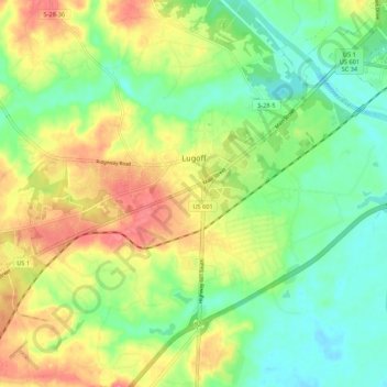
Name: Lugoff topographic map, elevation, terrain.
Location: Lugoff, Kershaw County, South Carolina, United States (34.18909 -80.75121 34.24891 -80.64290)
Average elevation: 226 ft
Minimum elevation: 115 ft
Maximum elevation: 381 ft
Kershaw County trails, hiking, mountain biking, running and outdoor activities
Make a donation
Gear up for your next adventure:
As an Amazon Associate, this site earns from qualifying purchases at no extra cost to you.
Other topographic maps
Click on a map to view its topography, its elevation and its terrain.
Battle of Camden National Historic Landmark
United States > South Carolina > Kershaw County > Flat Rock
Average elevation: 341 ft
Make a donation
Gear up for your next adventure:
As an Amazon Associate, this site earns from qualifying purchases at no extra cost to you.
Make a donation
Gear up for your next adventure:
As an Amazon Associate, this site earns from qualifying purchases at no extra cost to you.
Sunnyhill
United States > South Carolina > Kershaw County > Camden > Sunnyhill
Average elevation: 282 ft