
Ommersheim topographic map
Interactive map
Click on the map to display elevation.
About this map
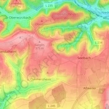
Name: Ommersheim topographic map, elevation, terrain.
Average elevation: 1,050 ft
Minimum elevation: 748 ft
Maximum elevation: 1,263 ft
Other topographic maps
Click on a map to view its topography, its elevation and its terrain.
Gräfinthal
Deutschland > Saarland > Saarpfalz-Kreis > Mandelbachtal
Gräfinthal, Bliesmengen-Bolchen, Mandelbachtal, Saarpfalz-Kreis, Saarland, 66399, Deutschland
Average elevation: 981 ft
Habkirchen
Deutschland > Saarland > Saarpfalz-Kreis > Mandelbachtal
Habkirchen, Mandelbachtal, Saarpfalz-Kreis, Saarland, Deutschland
Average elevation: 876 ft