Geolocate

Knoxville topographic map

Click on the map to display elevation.

About this map

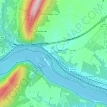
Name: Knoxville topographic map, elevation, terrain.

Location: Knoxville, Frederick County, Maryland, 41716, United States (39.30705 -77.68416 39.34705 -77.64416)

Average elevation: 466 ft

Minimum elevation: 217 ft

Maximum elevation: 1,237 ft

Frederick County trails, hiking, mountain biking, running and outdoor activities

Other topographic maps

Click on a map to view its topography, its elevation and its terrain.

Flat Run

United States > Maryland > Frederick County > Emmitsburg

Average elevation: 453 ft

Woodsboro

United States > Maryland > Frederick County

Average elevation: 404 ft

Clover Hill

United States > Maryland > Frederick County

Average elevation: 364 ft

Burkittsville

United States > Maryland > Frederick County

Average elevation: 610 ft

Rosemont

United States > Maryland > Frederick County

Average elevation: 449 ft

Green Valley

United States > Maryland > Frederick County

Average elevation: 505 ft

New Market

United States > Maryland > Frederick County

Average elevation: 499 ft

Gear up for your next adventure:

🗃️Trail First Aid Kit - Essential kit for outdoor injuries and emergencies
📻Weather Alert Radios - Stay informed of storm risks while off-the-grid
🏕️Tent Footprint - Protect your tent base from wear
🌎3D Topographic Globes - Raised relief globes for a tactile understanding of geography
🚗GPS Dash Cams - Record your scenic drives through mountain passes and canyons

As an Amazon Associate, this site earns from qualifying purchases at no extra cost to you.