
Make a donation
Gear up for your next adventure:
As an Amazon Associate, this site earns from qualifying purchases at no extra cost to you.
Thala topographic map
Click on the map to display elevation.
Make a donation
Gear up for your next adventure:
As an Amazon Associate, this site earns from qualifying purchases at no extra cost to you.
Thala
Thala (Arabic: تالة, romanized: Tāla) is a town and commune in Tunisia. It is located in the Kasserine Governorate since 1956. As of the 2004 census it had 13,968 inhabitants. The altitude of Thala is 1,017 metres (3,337 ft), which makes it the highest and the coldest town in the country.
Make a donation
Gear up for your next adventure:
As an Amazon Associate, this site earns from qualifying purchases at no extra cost to you.
About this map
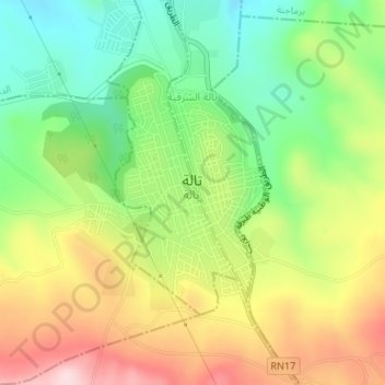
Name: Thala topographic map, elevation, terrain.
Location: Thala, تالة الغربية, معتمدية تالة, Kasserine, 1210, Tunisia (35.56255 8.65983 35.57924 8.67804)
Average elevation: 3,215 ft
Minimum elevation: 2,779 ft
Maximum elevation: 3,766 ft
Make a donation
Gear up for your next adventure:
As an Amazon Associate, this site earns from qualifying purchases at no extra cost to you.