
Aïn Taghrout topographic map
Interactive map
Click on the map to display elevation.
About this map
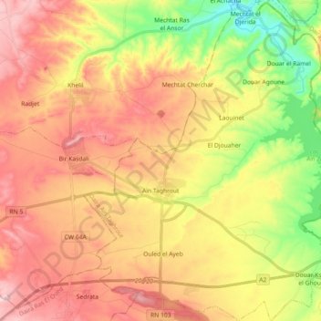
Name: Aïn Taghrout topographic map, elevation, terrain.
Location: Aïn Taghrout, Daïra Ain Taghrout, Bordj Bou Arreridj, Algérie (36.07199 5.03032 36.21744 5.19716)
Average elevation: 3,074 ft
Minimum elevation: 2,575 ft
Maximum elevation: 3,507 ft
La chaîne de montagne Draa el Haddad surplombe la ville à 1 016 mètres de moyenne avec le pic Kef Della à 1 044 mètres d'altitude.