
Make a donation
Gear up for your next adventure:
As an Amazon Associate, this site earns from qualifying purchases at no extra cost to you.
Hancock topographic map
Click on the map to display elevation.
Make a donation
Gear up for your next adventure:
As an Amazon Associate, this site earns from qualifying purchases at no extra cost to you.
About this map
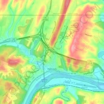
Name: Hancock topographic map, elevation, terrain.
Location: Hancock, Washington County, Maryland, 21750, United States (39.69251 -78.20656 39.72069 -78.14882)
Average elevation: 548 ft
Minimum elevation: 381 ft
Maximum elevation: 748 ft
Washington County trails, hiking, mountain biking, running and outdoor activities
Make a donation
Gear up for your next adventure:
As an Amazon Associate, this site earns from qualifying purchases at no extra cost to you.
Other topographic maps
Click on a map to view its topography, its elevation and its terrain.
Antietam National Battlefield
United States > Maryland > Washington County > Sharpsburg
Average elevation: 482 ft
Make a donation
Gear up for your next adventure:
As an Amazon Associate, this site earns from qualifying purchases at no extra cost to you.
Make a donation
Gear up for your next adventure:
As an Amazon Associate, this site earns from qualifying purchases at no extra cost to you.