

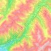
Serneus topographic map
Click on the map to display elevation.
About this map
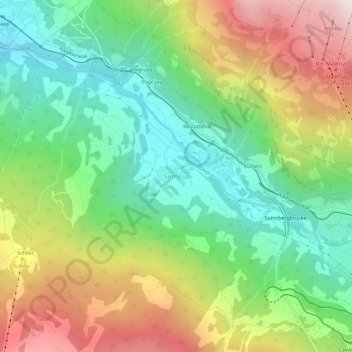
Name: Serneus topographic map, elevation, terrain.
Location: Serneus, Klosters, Prättigau/Davos, Grisons, 7249, Switzerland (46.86973 9.81884 46.90973 9.85884)
Average elevation: 4,485 ft
Minimum elevation: 2,904 ft
Maximum elevation: 6,969 ft
Other topographic maps
Click on a map to view its topography, its elevation and its terrain.
Davos
Switzerland > Grisons > Prättigau/Davos
The main village of Davos lies at the top of the narrow valley of the Landwasser at an altitude of 1,560 metres (5,120 ft), just below the Wolfgang Pass. Lake Davos is northeast of the village, formerly the source of the Landwasser.
Average elevation: 7,028 ft
Davos
Switzerland > Grisons > Prättigau/Davos
The main village of Davos lies at the top of the narrow valley of the Landwasser at an altitude of 1,560 metres (5,120 ft), just below the Wolfgang Pass. Lake Davos is northeast of the village, formerly the source of the Landwasser.
Average elevation: 7,028 ft
Davos
Switzerland > Grisons > Prättigau/Davos
The main village of Davos lies at the top of the narrow valley of the Landwasser at an altitude of 1,560 metres (5,120 ft), just below the Wolfgang Pass. Lake Davos is northeast of the village, formerly the source of the Landwasser.
Average elevation: 7,028 ft
Davos
Switzerland > Grisons > Prättigau/Davos
The main village of Davos lies at the top of the narrow valley of the Landwasser at an altitude of 1,560 metres (5,120 ft), just below the Wolfgang Pass. Lake Davos is northeast of the village, formerly the source of the Landwasser.
Average elevation: 7,028 ft

Davos
Switzerland > Grisons > Prättigau/Davos
The main village of Davos lies at the top of the narrow valley of the Landwasser at an altitude of 1,560 metres (5,120 ft), just below the Wolfgang Pass. Lake Davos is northeast of the village, formerly the source of the Landwasser.
Average elevation: 7,028 ft