Geolocate

Choras topographic map

Click on the map to display elevation.

About this map

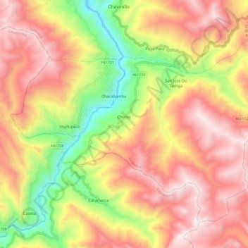
Name: Choras topographic map, elevation, terrain.

Location: Choras, Province of Yarowilca, Huánuco, Peru (-9.95923 -76.63575 -9.86760 -76.51865)

Average elevation: 12,428 ft

Minimum elevation: 10,230 ft

Maximum elevation: 14,167 ft

Other topographic maps

Click on a map to view its topography, its elevation and its terrain.

Churin

Peru > Huánuco > San Francisco de Asís

Average elevation: 12,070 ft

Vichaycoto

Peru > Huánuco > Pillco Marca

Average elevation: 7,162 ft

Tingo María

Peru > Huánuco > Rupa-Rupa > Tingo María

Average elevation: 2,654 ft

Maynas

Peru > Huánuco > Marías

Average elevation: 12,602 ft

Gear up for your next adventure:

🗺️Topographic Maps - Detailed topo maps for hiking, exploring and outdoor navigation
🔋Solar Power Banks - Keep your GPS and phone charged in remote wilderness areas
🗺️NatGeo Topo Maps - High-quality waterproof printed topographic maps of US Parks
📻Weather Alert Radios - Stay informed of storm risks while off-the-grid
🛠️Backpacking Tool Kit - Essential toolkit for outdoor repairs

As an Amazon Associate, this site earns from qualifying purchases at no extra cost to you.