
Make a donation
Gear up for your next adventure:
As an Amazon Associate, this site earns from qualifying purchases at no extra cost to you.
Forest City topographic map
Click on the map to display elevation.
Make a donation
Gear up for your next adventure:
As an Amazon Associate, this site earns from qualifying purchases at no extra cost to you.
Forest City
Forest City was officially founded in 1855. Formerly known as “Puckerbrush”, Robert Clark the official founder/surveyor deemed it “Forest City” because it was cut right out of the trees. It was then platted in 1856, and later incorporated on June 14, 1878. The population started to grow when immigrants from Sweden and Norway settled in the Forest City area because of the similar topography. Its growth continued as city leaders convinced the Minneapolis and St. Louis Railroad to come through Forest City. Although the Civil War stunted the area's growth, many immigrants found the city attractive. Later on churches, banks, a college (Waldorf University), electricity, and the telephone turned Forest City into an ideal country town. In 1960, investors took over a failing travel trailer factory and created Winnebago Industries, creating what would become one of the largest employers in the region and causing the population to grow. Winnebago's corporate headquarters were later relocated to Eden Prairie, Minnesota causing the population to decline. Today, Forest City's population is around 4,200.
Make a donation
Gear up for your next adventure:
As an Amazon Associate, this site earns from qualifying purchases at no extra cost to you.
About this map
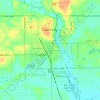
Name: Forest City topographic map, elevation, terrain.
Location: Forest City, Winnebago County, Iowa, 50436, United States (43.22488 -93.65625 43.27860 -93.61542)
Average elevation: 1,227 ft
Minimum elevation: 1,188 ft
Maximum elevation: 1,302 ft
Winnebago County trails, hiking, mountain biking, running and outdoor activities
Make a donation
Gear up for your next adventure:
As an Amazon Associate, this site earns from qualifying purchases at no extra cost to you.